The Peninsula, Maylands
Pre-Colonisation
The Wadjuk Noongar people are the Traditional Custodians of the Maylands/Bayswater area. The Noongar people were nomadic hunter-gatherers, moving frequently as they followed the seasons and food sources, at the time of European settlement, it is believed the Noongar people spoke 13 dialects. The Swan River holds special significance to the Noogar people as they believe that a Wagyl - a snakelike being from the Dreamtime, meandered over the land creating the rivers.
Post-1829
In 1829, Governor James Stirling had reserved two “peninsulas” on the river, east of Perth, one on either side. That on the right was for a racecourse, but his plans for the other are not at present known. Henry Camfield, who arrived on the Caroline on the 12th of October 1829, was given the reserve on the left bank. Henry was single, aged 29 years old, and had arrived from Kent, with labourers and servants. He was described as an 'agriculturist'. He planned to grow hops for beer, an aim that was favoured by Stirling, who hoped that a supply of beer would lessen the excessive drinking of rum and other spirits that was then prevalent among the “lower classes”.
When the Clarksons and the Hardeys arrived with their chartered ship, bringing with them tradesmen, farmers, servants, livestock, seeds, implements, and their expert knowledge of farming, Stirling decided to sacrifice the projected racecourse so that they could have land close to Perth, and the area was given the name of “The Peninsula” or 'Peninsula Farm'.
The whole of the peninsula was then granted the Tranby folk by Governor James Stirling when they arrived in February 1830. They were staunch Wesleyans and were very happy to work together. Many were only given small allotments from the land to which they were entitled, until more land had been explored and released in the Colony. The actual sub-division of the land was left to the Tranby and a plan was submitted to the Governor at the end of the year. The size and location of the original Grants, assigned to the Tranby folk, can be appreciated by examining the annotated Google image below:
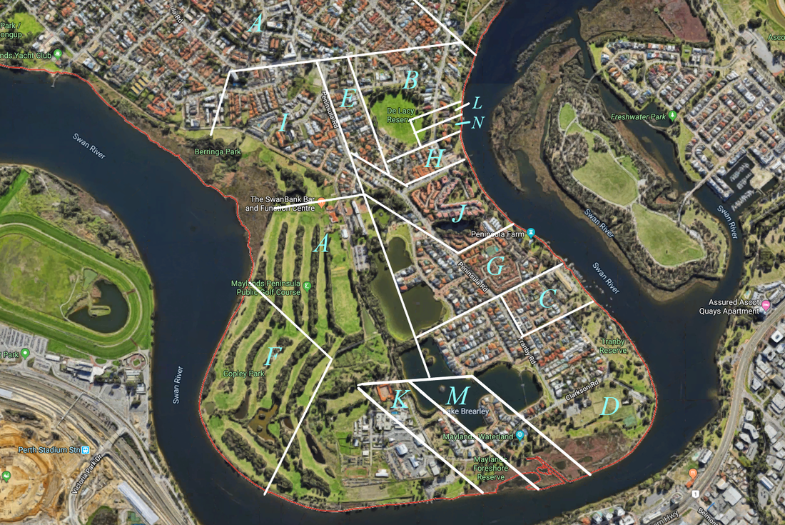
Original Grand labels overlaid upon 2019 Google Maps Satellite image.
Details of the original Grants, taken from the supportive text recorded on surveyor George Johnson's 1835 Map, are as follows:
- A Michael & James Smith Clarkson 172.7 Acres
- B Michael & James Smith Clarkson 20.0 Acres
- C Michael & James Smith Clarkson 12.2 Acres A+B+C= 205.0 Acres
- D John Wall Hardey 94.2 Acres
- E John Wall Hardey 8.0 Acres D+E= 102.2 Acres
- F Joseph Hardey 56.0 Acres
- G Joseph Hardey 38.0 Acres Site of the Present day 'Tranby House'
- H Joseph Hardey 8.0 Acres F+G+H= 102 Acres
- I Thomas Hurrey 21.0 Acres
- J George Johnson 20.2 Acres
- K John Thompson 18.2 Acres
- L John Thompson 2.0 Acres K+L = 20.2 Acres
- M Elizabeth Rowland 18.2 Acres
- N Elizabeth Rowland 2.0 Acres M+N= 20.2 Acres
The Original Farm Plan
George Johnson's 1835 map is reproduced below in two sections:
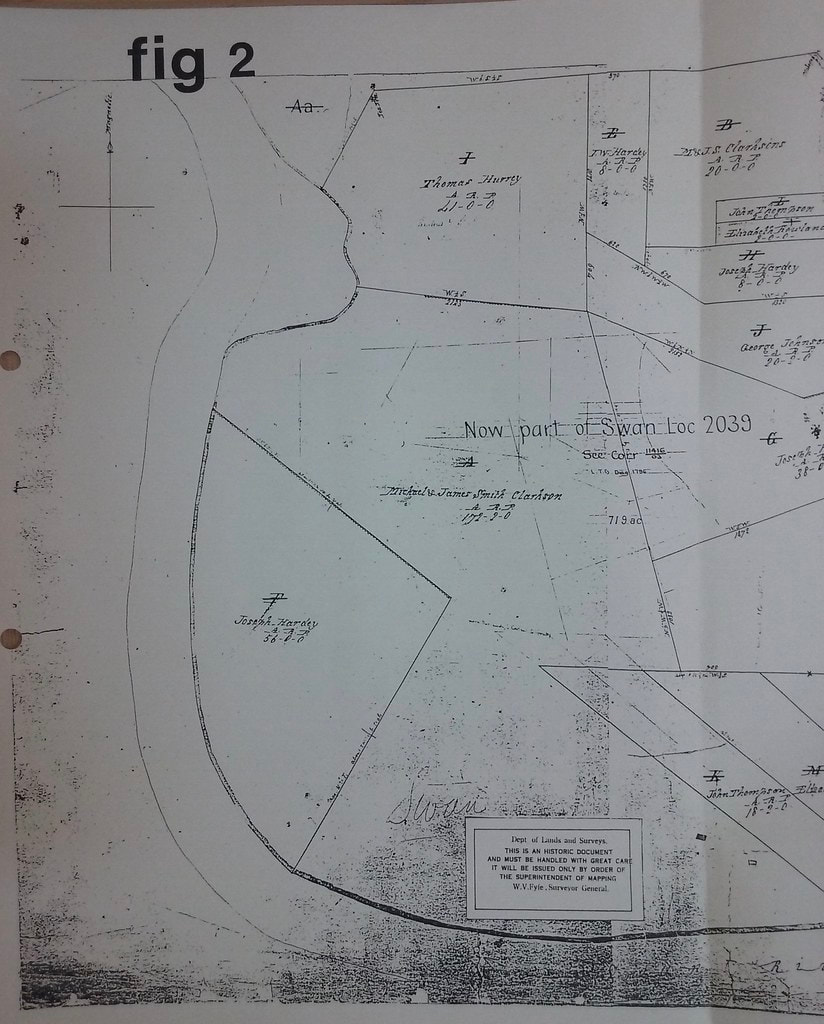
The left section of George Johnson's 1835 Map of the Peninsula.
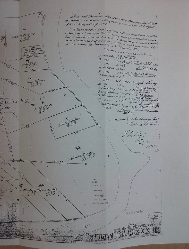
The right section of George Johnson's 1835 Map of the Peninsula.
A reproduction of the right hand section of the 1835 map, reproduced above, contains information of the Farm's division into grants and the signatures of the grantees. It was signed on the 24 July 1835. It updates the original Farm plan, that was approved by His Excellency the Governor on the 31st December 1830. The document is signed by many of the original Grantees and signed 'for' the grantees that were literate.

The Perth 1832 map, reproduced above, shows the Peninsula Grants in relation to the developing town of Perth. It shows the track to Guildford and the branch of the track to the Peninsula.

Brickworks
It is known the Joseph Hardey built his third house (the current 'Tranby House') of burnt bricks using the Peninsula clay. The site was used later and became known as Grays Brickworks founded by Henry Gray (born 1800). It operated for some years from 1851 to 1857 until the pit was flooded. Thirty-one ‘Ticket-of- leave’ convicts were employed at his premises.
The year 1885 saw the establishment of the second brickworks: 'The Peninsular Brickworks' This was established by a group of businessmen led by a Mr Wright of the building firm: Wright & Patterson. The company also established a jetty. By 1905, the brickworks were purchased by Mills and Sons for use as pottery works.
The year 1885 saw the establishment of the second brickworks: 'The Peninsular Brickworks' This was established by a group of businessmen led by a Mr Wright of the building firm: Wright & Patterson. The company also established a jetty. By 1905, the brickworks were purchased by Mills and Sons for use as pottery works.
By 1909, H. J. Mills and Company had established pottery works at lot 548 Clarkson Road on the Peninsula, now Maylands Waterland. It emerged as the main Western Australian supplier of ceramic pipes and pottery items. Mills Pottery was a famous concern, which imported clay by boat and only had to use a portion of Peninsula clay. In about 1928, this factory was sold to Lance Brisbane and became part of Brisbane & Wunderlich extensive company.
|
A new brickworks opened in 1927 developed by Robert Law and King Atkins. The only other significant structure at the time was the Maylands Aerodrome, and both were surrounded by farmland. The Maylands site was considered ideal as the peninsula had an abundance of clay and was close to the Perth central business district but isolated from suburban residential areas. In the 1940s, it was claimed to be one of the most modern operations in Australia at that time. Construction works were extensive, excavating two large-scale clay pits, two large Hoffman kilns, and an assembly of drying sheds. From the 1920s to the 1980s, a 2 foot gauge tramway was owned and operated by the Metropolitan Brick Company Ltd. When the Maylands plant was in full production it employed in excess of 130 employees, most of whom lived in the vicinity of the works.
|
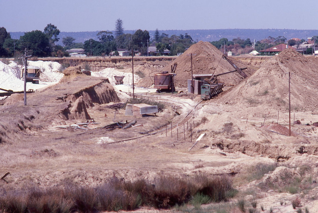
Overall view of the brickworks by Jim Bisdee looking north and south respectively from Johnson Road in 1980. Also highlights the two different types of clay being quarried.
|
During the 1968 Meckering earthquake, one of the kilns was damaged, and subsequently demolished. Operations ceased in 1983, with plans to demolish the site. (Wikipedia) Metropolitan Brick Holdings Ltd. as it was now known was officially acquired by H. L. Brisbane & Wunderlich Ltd. (Bristle) in October 1973. Maylands Brickworks was finally shut down just prior to Christmas 1982 and the land was sold to the City of Stirling in 1983.
Auction Sale -1930

A detailed map of Land to be Auctioned on the Peninsula in the 1930s (via the State Library of WA)
In the 1930, residential blocks on the Peninsula were available, for a deposit of one Shilling and five pence [$7.00 @ 2019 value] with the remainder of your successful bid to be paid with an interest of 6% per year over 5 years. The Peninsula settled by the 30 or so Tranby folk is now home to thousands of people.
Health Food Factory
In the 1930's the Sanatorium Health Food Company established a factory on the Peninsula to process malt extracts from the Swan Brewery. It closed in the 1950's. The factory used a large quantity of water and a large drain, leading to the river, was constructed. It is still there today.
Maylands Aerodrome
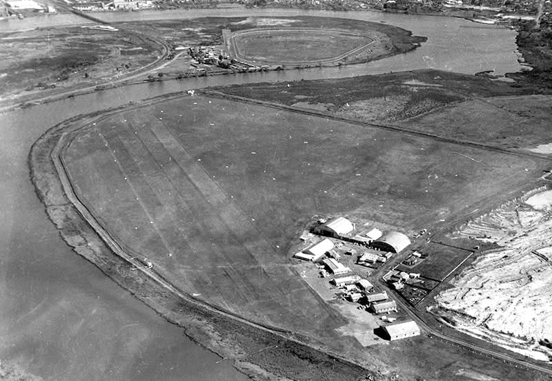
The 1924 Maylands Aerodrome - This September 1961 view shows the Swan River along the airfield boundary, levee bank and layout of the grass runways.
Geoff Goodall collection
Following a need to establish a regular Air Mail service negotiations to acquire land were carried out by Commonwealth Government departments. An area of flat farming ground on the Maylands Peninsular on the Swan River was selected, 131 acres (52 hectares) of approximately rectangular shape being acquired by the Commonwealth Government and Gazetted in November 1923 as the site for Maylands Aerodrome. The purchase was despite the ominous Commonwealth Surveyor's report which was to haunt officialdom for the next 40 years:
"The land is mostly low-lying and during the winter months apparently gets very soft and sticky. The surface is somewhat rough, a great part having been ploughed at one time and cattle grazing over it when wet has cut it up rather badly. There was no surface water at the time of the survey except a little near the North West corner of Lot 532 and that was fast drying up. There are several drains traversing this land which have their greatest depth of two feet near the river."
The aerodrome was built, and it covered parts of the original Lot 'A' (Michael & James Clarkson) and Lot 'F' (Joseph Hardey)
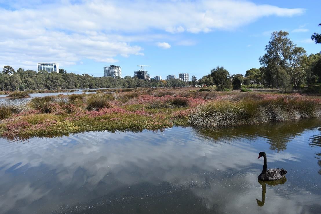
The ecologically important Maylands Samphire Flats located along the southside of the Peninsula. - Via Councillor Elli Peterson Pik.
Samphire Flats
The City of Bayswater has recently released a 10-year conservation plan for the Maylands Samphire Flats (located at the end of the peninsula, adjacent to Clarkson Reserve), as part of their long-term commitment to restore the 11km stretch of the Swan River foreshore. It extends through the original Land Grants assigned to John Thompson Lot 'K'; Elizabeth Rowland Lot 'M', and John Wall Hardey. Lot 'D'.